The ocean floor has been hiding secrets under its waves for a long time, and scientists have recently uncovered how some of these anomalies can be used as natural time markers to understand the geological and climatic events that have shaped our planet.
Magnetic Stripes: Earth’s Geological Tape Recorder
One of the most convincing discoveries in marine geology is the symmetrical magnetic stripes flanking mid-ocean ridges. These stripes are the result of seafloor spreading, where molten rock comes out at the ridges, cools, and solidifies, capturing the Earth’s magnetic field orientation at that time. Periodic reversals in Earth’s magnetic field polarity are recorded in these basaltic rocks, creating a pattern of alternating magnetic anomalies. These patterns have been used to determine the age of oceanic crust and the rate of seafloor spreading, effectively acting as a geological chronometer.
Gravity Anomalies: Mapping Subsurface Structures
Beyond magnetic signatures, variations in Earth’s gravity field over the ocean basins have revealed significant anomalies. These gravity anomalies are caused by differences in mass distribution beneath the seafloor, such as underwater mountains, trenches, and other geological structures. Using satellite altimeter data, scientists can image these features to a very high resolution. One of the most famous “gravity holes” is in the Indian Ocean, with a deep geoid depression that has been associated with ancient structures in the mantle and thus helps scientists understand Earth’s geological history.
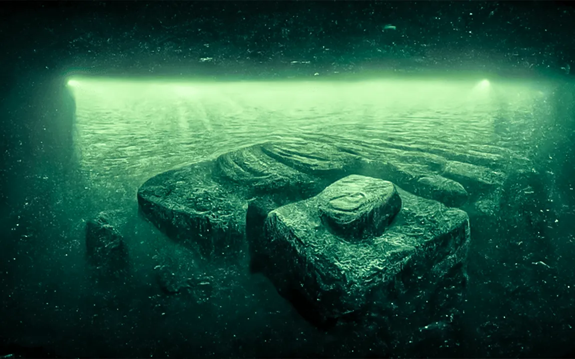
The Baltic Sea Anomaly: A Case Study in Seafloor Mysteries
In 2011, the Ocean X Team was able to find a bizarre structure on the bottom of the Baltic Sea, resembling the Millennium Falcon spacecraft in the “Star Wars” movie. Various speculations arose from a sunken UFO to a simple natural geological formation. Later analysis results revealed that the structure may probably be a glacial deposit with rocks transported and deposited by glacial movements during the Ice Age. This example makes it evident that proper scientific analysis is needed when interpreting seafloor anomalies and their significance in history.
Using Anomalies as Chronological Markers
The study of these ocean floor anomalies has presented a unique method of marking geological time. Magnetic stripes provide for the reconstruction of plate movements and the history of Earth’s magnetic field reversals. Gravity anomalies help identify subsurface structures, giving clues about tectonic activities and sediment deposition over millions of years. Data from these anomalies can be integrated to help construct detailed timelines of Earth’s geological and climatic evolution.
Advances in Technology for Improved Temporal Mapping
The new advanced technologies include high-resolution satellite altimetry and deep-sea submersibles. High-resolution satellite altimetry is capable of accurately measuring sea surface height. Minute variations due to underlying geological structures are now detected by such a device. It can therefore provide detailed gravity maps that unveil hidden features covered by thousands of meters of seawater. Direct observation and sampling of seafloor formations can be made through deep-sea submersibles. This, therefore, can give ground-truth data complementing remote sensing techniques.
Implications for Earth Sciences
The knowledge of ocean floor anomalies as time markers has important implications across many fields of Earth sciences. For geology, it helps in reconstructing the movements of tectonic plates and the formation of ocean basins. For paleoclimatology, sediment deposits associated with these anomalies can provide records of past climate conditions. Moreover, in natural resource exploration, identification of specific geological formations can guide the search for mineral and hydrocarbon deposits.
Challenges and Future Directions
The temporal understanding offered by ocean floor anomalies is impressive, but challenges do exist. Large parts of the oceans are still largely unmapped, and the interpretation of this data depends on careful consideration of several geological processes in order to not misattribute data. Future work will combine multidisciplinary methods that include the integration of geophysical data, geochemical analyses, and computer modeling to improve the accuracy and resolution of seafloor mapping.
Conclusion
Ocean floor anomalies serve as natural archives of Earth’s history, providing a novel way to mark geological time. Through the study of magnetic stripes, gravity variations, and unique seafloor formations, scientists can unravel the complex narrative of our planet’s past. As technology advances, our ability to decode these underwater time markers will continue to improve, offering deeper insights into the dynamic processes that have shaped Earth over millions of years.