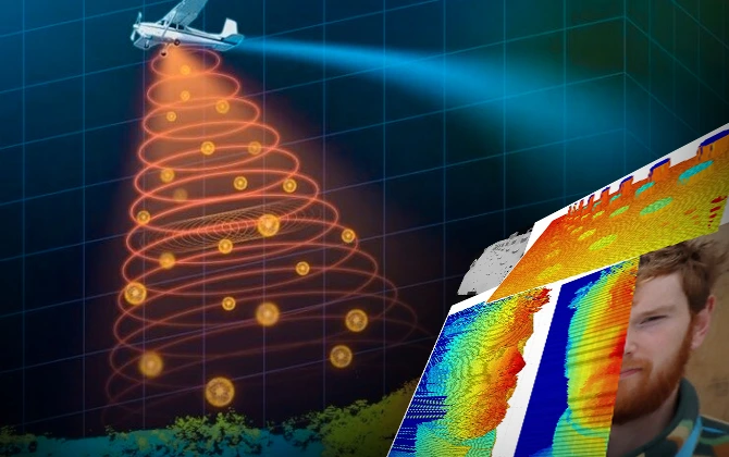
Researchers have recently developed a single-photon LiDAR system that captures high-resolution 3D images at distances of up to one kilometer. It promises to further enhance security, monitoring, and remote sensing applications in challenging environments.
Understanding LiDAR and Its Evolution
LiDAR stands for Light Detection and Ranging. It is a remote sensing system that applies laser light in range determination. LiDAR sends out laser pulses and examines the backscattered signals for the generation of detailed 3D pictures about the areas of interest. Conventionally, it has been utilized in topographic mapping, forestry, and even in autonomous vehicle navigation.
The new system works on a single-photon time-of-flight method to optimize this effect. Here, the distance to measure is determined by measuring the time elapsed from the moment a laser pulse leaves a point until it reflects back to that point. Then, this process is repeated at several sampling points to create very detailed 3D images.
Innovations in the Newly Developed System
The research team made improvements in various departments to gain superiority:
- Advanced Single Photon Detector: It has a superconducting nanowire single photon detector that is about two times more efficient compared to that found in prior LiDARs. Higher efficiency means gathering twice the number of scattered photons for a given target, increasing the spatial resolution.
- Improved Timing Resolution: The system has a timing resolution at least ten times better than its predecessors. This allows the system to distinguish surfaces separated by about one millimeter in depth from a distance of 325 meters, which makes it possible to capture fine details in 3D images.
- Eye-Safe Operation: The system operates at a wavelength of 1550 nanometers, using laser powers that are low enough to be considered eye-safe. This is an important feature for practical applications, where safety is critical but performance must be maintained.
Field Testing and Results
The researchers conducted field tests on the Heriot-Watt University campus, testing the system’s capabilities at distances of 45 meters, 325 meters, and one kilometer. They tested spatial and depth resolution with a custom pillar-based 3D-printed target of differing pillar sizes and heights. Outstandingly, at both 45 and 325 meters, daylight was resolved in features as small as one millimeter. This system also provided a recognizable image of a human face at a distance of 325 meters acquired in a minimal acquisition time by minimal data processing.
Future Applications and Outlook
This technology provides many opportunities for applications:
- Security and Surveillance: The system can obtain high-resolution depth images through smoke, fog, or cluttered scenes. This makes its usage highly suitable for monitoring through difficult conditions.
- Infrastructure Monitoring: In what concerns the very high depth resolution, this system is ideal in detection of minute movements at structures such as buildings or rock faces, helping in hazard assessment.
- Environmental Sensing: The ability to image objects behind obstacles like foliage or camouflage netting could benefit environmental studies and wildlife monitoring.
Looking ahead, the research team plans to extend the system’s range to up to 10 kilometers and explore imaging through atmospheric obscurants like smoke and fog. They also aim to develop advanced computational methods to accelerate data analysis, enabling the imaging of more distant scenes.
Conclusion
This single-photon LiDAR system stands as a pinnacle in remote sensing development, enabling remote ultra-high-resolution 3D imaging at notable distances while being eye safe. These attributes make it particularly important in many fields. Consequently, further research would always lead to additional improvements in the functionalities and applications of this system, contributing to further developments in security, environmental monitoring, and more.